
下载App
资质规则
旅行
账户
SQKrisflyer
BBQ (beautiful, breath-taking, quaint) Mashū Blue lake!
摩周湖的点评
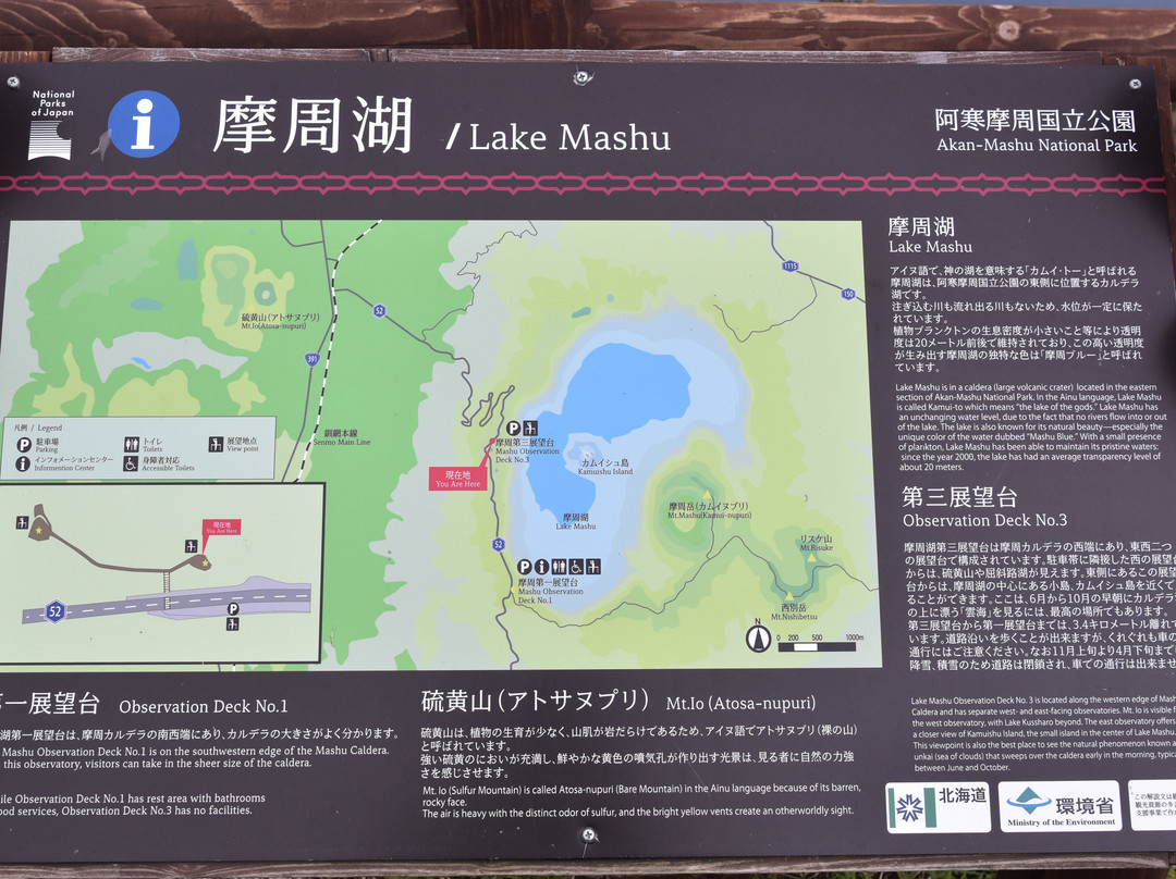
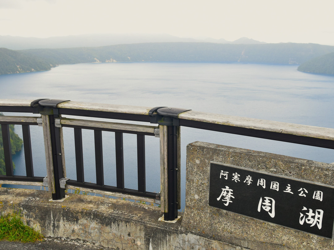
点评:In the indigenous Ainu language, Lake Mashū (摩周湖, Mashūko) is referred to as “Kamui-to” which translates to “the lake of the gods”. Similar to Lake Kussharo and Lake Akan in the Akan Mashu National Park, Lake Mashū is a caldera lake formed by water filling the caldera, the latter depression is created from the inward collapse of the empty magma chamber roof of the erupted volcano. Subsequent secondary eruption then produced a volcanic cone at the centre of the caldera in which the cone tip now appears as a tiny 30-metre high volcanic island – Kamuishu Island (“Kamuishu” translated in Ainu as “the old woman who became a god”) based on a legend. Just next to Lake Mashū is a small crater that was formed from outward eruption of rocks and other materials from a smaller volcano; this crater is named Mount Mashū (Mashudake) or Mount Kamui or “Kamui-nupuri” in the Ainu language meaning “mountain of God”. Sources have stated that Lake Mashū is sixth biggest caldera lake in Japan – it is 351 metres above sea level, has a maximum depth of 211 metres and has a water surface area of 19 square kilometres. According to the information board, “Lake Mashū has an unchanging water level, due to the fact that no river flows into and out of the lake” and “With a small presence of plankton, Lake Mashu has been able to maintain its pristine waters; since the year 2000, the lake has an average transparency level of about 20 metres” which makes Lake Mashū as one of the clearest lakes in the world, if not the clearest lake. Due to safety reasons of the 200 to 300 metres high precipitous slopes and the fog which blankets the lake at least 100 days in a year, nobody can go down to the lake. Because of the fog (occurs most in June and July), Lake Mashū is also given the name of Kiri no Mashuko (translated as "Foggy Lake Mashū ").
The kidney-shaped Lake Mashū can be viewed at three observatory or lookout points: Observatory Number 1 (south western edge), Observatory Number 3 (western edge) and Uramashu Observatory (north eastern edge, “ura” translates to “opposite side” hence on the opposite side of Observatory Number 1 and 3). As one of the several attractions in our 10-day Hokkaido self-drive vacation, my family and I spent about 2 hours at Observatory Number 1 and Number 3 in the mid-afternoon of a cloudy day. We did not have time to go to Uramashu observatory and we read about the limited view of Lake Mashū from this observatory which can be a blessing in the event of the fog since it is at a lower altitude below the fog.
Getting there: We drove to Lake Mashū from Mount Io (Atosanupuri) relying on Apple Maps on the Apple Car Play in our rental car. After negotiating the hairpin mountain Highway 52, we reached Observatory Number 3 first and then later drove a further 3.4 km down to Observatory Number 1. Observatory Number 1 car park has some 130 parking lots for cars which is free parking from 1 November to 30 April but charges ¥500 from 1 May to 31 October. If you pay ¥500 at Observatory Number 1, then you can park for free at Mount Io car park by showing the parking ticket and vice versa; note that the validity of free parking at second attraction is for two days. On the other hand, it is free parking throughout the year at the Observatory Number 3 car park with some 20 designated diagonal parking lots and undesignated parking lots for another 12 cars along Highway 52.
Alternatively, you could take the train on the JR Senmou Line (connecting Kushiro and Abashiri), alight at the Mashū Station and then take the Mashuko Line bus to Lake Mashū Observatory Number 1 which takes about 20 – 25 minutes); there are 2 buses per day from April to mid-July and 4 buses per day from mid-July to mid-October. You could also take Akan Bus from Kushiro Station which includes a 30-minute stopover at Observatory Number 1 from April to October. There is no bus that takes you to Observatory Number 3.
The Lake Attraction
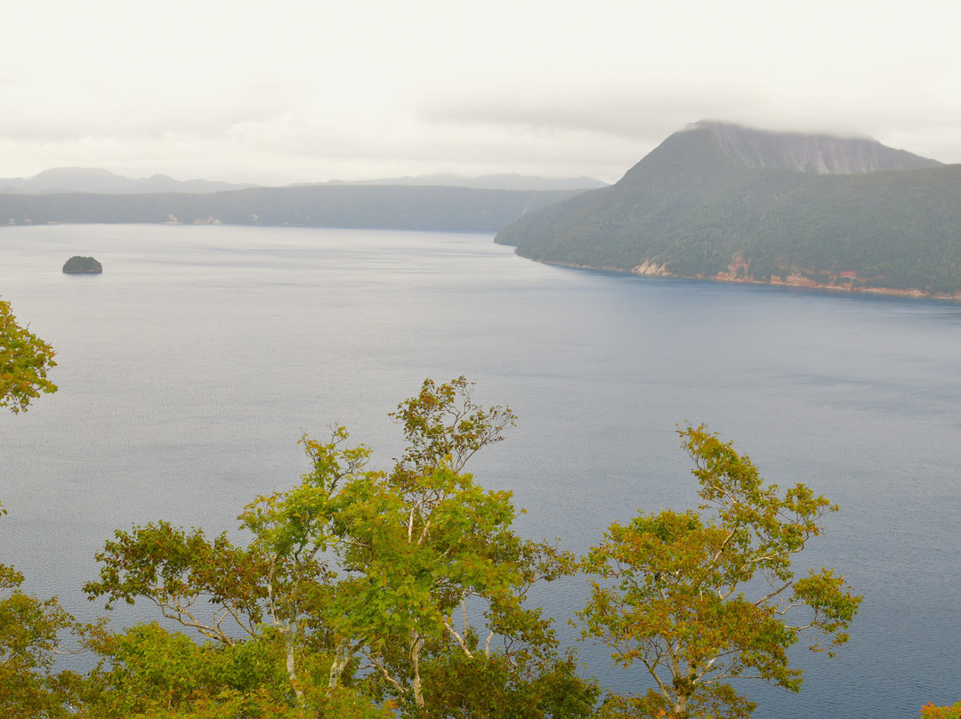
When we reached the observatory decks, the beautiful view of Lake Mashū, Kamuishu Island, Mount Mashū crater and forest in front of us never for once failed to take our breath away! Lake Mashū has this special deep blue colour that I have never seen before in any lake – the locals called it “Mashū Blue” while my internet search maps/matches the lake’s deep blue colour closest to medium sapphire blue on the cloudy day when we were there. What makes it more special is that the blue hue can change depending on the season and the weather conditions (for example deep sapphire blue on a sunny day). Furthermore, the deep blue water blended so well with the green colour of the forest. I could not help but just keep taking lots of photos on my DSLR camera using a wide-angle lens and my handphone using the “panorama” mode.
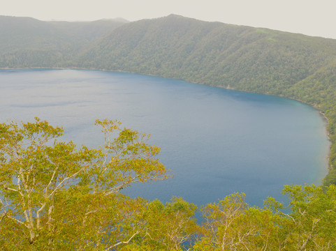
Observatory Number 3 (摩周湖第3展望台) - after crossing the road and climbing some stairs, we reached a juncture where we saw two observatory decks; one on the right (east facing) some 20 metres away and another one on the left (west facing) that is about 100 metres away and requires about 2 minutes’ walk along a wooden fenced pathway. We walked to both and found the left west facing observatory deck to have a more expansive view of the entire Lake Mashū, a closest view of both Kamuishu Island and Mount Kamui crater as well as the sloping shoreline - never knew 100 metres can make such a difference. Interestingly, the left west facing observatory deck has an elevated “upper” viewing platform and a lower viewing platform. However, there are two parts that are hidden from our view at this observatory deck - the north eastern part of Lake Mashū (which can be seen at the Urumashu Observatory) and the inside of the Mount Mashū crater (which can be seen from Observatory Number 1). There is also a bonus – you get a fabulous view of Mount Io when you turn around and look in the opposite direction to that of Lake Mashū (you cannot get this view at Observatory Number 1). Do note that there are no facilities (e.g. toilet, café) at Observatory 3.
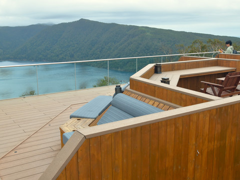
Observatory Number 1 (摩周湖第1展望台) – after climbing the wide staircase from the car park, we could go to two observatory decks. The one on the right is the special Mashū Kamuy Terrace observation deck (Mashū Kamuy Terrace was re- opened in 2022) while the one on the left is about 60 metres away and requires about 1-2 minutes’ walk. The left observatory has breathtaking views of the inside of the Mount Kamui crater as well as the southern edge or part of Lake Mashū. At the Mashū Kamuy Terrace observation deck, we saw wooden chairs, tables as well as special blue sofa seats that are inclined at about 45 degrees so that you could lie back and look at the clear starry night sky. The other special feature at the Mashū Kamuy Terrace observation deck is the clear glass panels that allows uninterrupted views of the lake. In any case, the observation decks at Observatory Number 1 are much closer to Lake Mashū (about 250 metres) than those at Observatory Number 3 and Urumashu Observatory. According to the information board, this observatory is the start of two trails to the 857-metre high summit of Mount Kamui (3 hours one way) and the 799-metre high summit of Mount Nishibetsu (2 hours 45 minutes one way).
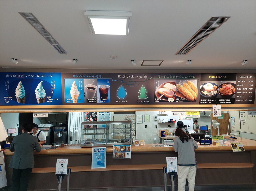
After admiring the breathtaking views and wanting some respite from the cold weather and the wind, we went down to the Kamuy Terrace shop cum restaurant/café and ate. The displayed menu is in Japanese but I saw the café sell maize, sausage rice, deep fried potato dumplings (imodango) and soft serve ice cream. You have to try the famous black cone Mashū Blue soft serve ice cream made with local milk and Ramune (Japanese non-alcoholic carbonated soft drink) in an original soda flavour (¥450) or mix of original Mashū Blue and vanilla ice cream (¥500). The shop was also selling Hokkaido melons from ¥6800 to ¥12800 when we were there. A local gift or specialty that can be bought here is the Lake Mashū Kamui Terrace Langue de Chat which is white chocolate sandwiched between two round langue de chat cookies, the latter kneaded with fresh caramel cream.
We enjoyed the following:
(1) we were thankful that there was no fog or mist when we were at both observatories but just clouds covering the top of Mount Kamui crater
(2) refreshing of our tired bodies by the gentle wind and the cold (about 15 degrees Celsius)
(3) harmonious Mother Nature elements of water (lake), mountain, sky and floral (trees, plants, grass)
(4) construction of Observatory Number 1 and 3 that provides different views enabling a better appreciation of Lake Mashū, Mount Kamui and its surrounding floral.
(5) Observatory Number 1 has much less tourists and visitors and is more peaceful.
Lake Mashū is considered by many to be the most beautiful lake in Japan – I could not agree more. So this attraction is a “must visit” in any season when you are at the Akan Mashu National Park or in Hokkaido for that matter. In fact, I would recommend that you visit nearby Mount Io, Lake Kussharo and Lake Akan (and even Lake Onnetō) before or after Lake Mashū. Do check the weather forecast for fog and rain (and also for “sea of clouds” at Observatory Number 3) before you go and bring along a jacket if you visit Lake Mashū Observatory 1 and Observatory 3 on a windy and cold day.
The kidney-shaped Lake Mashū can be viewed at three observatory or lookout points: Observatory Number 1 (south western edge), Observatory Number 3 (western edge) and Uramashu Observatory (north eastern edge, “ura” translates to “opposite side” hence on the opposite side of Observatory Number 1 and 3). As one of the several attractions in our 10-day Hokkaido self-drive vacation, my family and I spent about 2 hours at Observatory Number 1 and Number 3 in the mid-afternoon of a cloudy day. We did not have time to go to Uramashu observatory and we read about the limited view of Lake Mashū from this observatory which can be a blessing in the event of the fog since it is at a lower altitude below the fog.
Getting there: We drove to Lake Mashū from Mount Io (Atosanupuri) relying on Apple Maps on the Apple Car Play in our rental car. After negotiating the hairpin mountain Highway 52, we reached Observatory Number 3 first and then later drove a further 3.4 km down to Observatory Number 1. Observatory Number 1 car park has some 130 parking lots for cars which is free parking from 1 November to 30 April but charges ¥500 from 1 May to 31 October. If you pay ¥500 at Observatory Number 1, then you can park for free at Mount Io car park by showing the parking ticket and vice versa; note that the validity of free parking at second attraction is for two days. On the other hand, it is free parking throughout the year at the Observatory Number 3 car park with some 20 designated diagonal parking lots and undesignated parking lots for another 12 cars along Highway 52.
Alternatively, you could take the train on the JR Senmou Line (connecting Kushiro and Abashiri), alight at the Mashū Station and then take the Mashuko Line bus to Lake Mashū Observatory Number 1 which takes about 20 – 25 minutes); there are 2 buses per day from April to mid-July and 4 buses per day from mid-July to mid-October. You could also take Akan Bus from Kushiro Station which includes a 30-minute stopover at Observatory Number 1 from April to October. There is no bus that takes you to Observatory Number 3.
The Lake Attraction
When we reached the observatory decks, the beautiful view of Lake Mashū, Kamuishu Island, Mount Mashū crater and forest in front of us never for once failed to take our breath away! Lake Mashū has this special deep blue colour that I have never seen before in any lake – the locals called it “Mashū Blue” while my internet search maps/matches the lake’s deep blue colour closest to medium sapphire blue on the cloudy day when we were there. What makes it more special is that the blue hue can change depending on the season and the weather conditions (for example deep sapphire blue on a sunny day). Furthermore, the deep blue water blended so well with the green colour of the forest. I could not help but just keep taking lots of photos on my DSLR camera using a wide-angle lens and my handphone using the “panorama” mode.
Observatory Number 3 (摩周湖第3展望台) - after crossing the road and climbing some stairs, we reached a juncture where we saw two observatory decks; one on the right (east facing) some 20 metres away and another one on the left (west facing) that is about 100 metres away and requires about 2 minutes’ walk along a wooden fenced pathway. We walked to both and found the left west facing observatory deck to have a more expansive view of the entire Lake Mashū, a closest view of both Kamuishu Island and Mount Kamui crater as well as the sloping shoreline - never knew 100 metres can make such a difference. Interestingly, the left west facing observatory deck has an elevated “upper” viewing platform and a lower viewing platform. However, there are two parts that are hidden from our view at this observatory deck - the north eastern part of Lake Mashū (which can be seen at the Urumashu Observatory) and the inside of the Mount Mashū crater (which can be seen from Observatory Number 1). There is also a bonus – you get a fabulous view of Mount Io when you turn around and look in the opposite direction to that of Lake Mashū (you cannot get this view at Observatory Number 1). Do note that there are no facilities (e.g. toilet, café) at Observatory 3.
Observatory Number 1 (摩周湖第1展望台) – after climbing the wide staircase from the car park, we could go to two observatory decks. The one on the right is the special Mashū Kamuy Terrace observation deck (Mashū Kamuy Terrace was re- opened in 2022) while the one on the left is about 60 metres away and requires about 1-2 minutes’ walk. The left observatory has breathtaking views of the inside of the Mount Kamui crater as well as the southern edge or part of Lake Mashū. At the Mashū Kamuy Terrace observation deck, we saw wooden chairs, tables as well as special blue sofa seats that are inclined at about 45 degrees so that you could lie back and look at the clear starry night sky. The other special feature at the Mashū Kamuy Terrace observation deck is the clear glass panels that allows uninterrupted views of the lake. In any case, the observation decks at Observatory Number 1 are much closer to Lake Mashū (about 250 metres) than those at Observatory Number 3 and Urumashu Observatory. According to the information board, this observatory is the start of two trails to the 857-metre high summit of Mount Kamui (3 hours one way) and the 799-metre high summit of Mount Nishibetsu (2 hours 45 minutes one way).
After admiring the breathtaking views and wanting some respite from the cold weather and the wind, we went down to the Kamuy Terrace shop cum restaurant/café and ate. The displayed menu is in Japanese but I saw the café sell maize, sausage rice, deep fried potato dumplings (imodango) and soft serve ice cream. You have to try the famous black cone Mashū Blue soft serve ice cream made with local milk and Ramune (Japanese non-alcoholic carbonated soft drink) in an original soda flavour (¥450) or mix of original Mashū Blue and vanilla ice cream (¥500). The shop was also selling Hokkaido melons from ¥6800 to ¥12800 when we were there. A local gift or specialty that can be bought here is the Lake Mashū Kamui Terrace Langue de Chat which is white chocolate sandwiched between two round langue de chat cookies, the latter kneaded with fresh caramel cream.
We enjoyed the following:
(1) we were thankful that there was no fog or mist when we were at both observatories but just clouds covering the top of Mount Kamui crater
(2) refreshing of our tired bodies by the gentle wind and the cold (about 15 degrees Celsius)
(3) harmonious Mother Nature elements of water (lake), mountain, sky and floral (trees, plants, grass)
(4) construction of Observatory Number 1 and 3 that provides different views enabling a better appreciation of Lake Mashū, Mount Kamui and its surrounding floral.
(5) Observatory Number 1 has much less tourists and visitors and is more peaceful.
Lake Mashū is considered by many to be the most beautiful lake in Japan – I could not agree more. So this attraction is a “must visit” in any season when you are at the Akan Mashu National Park or in Hokkaido for that matter. In fact, I would recommend that you visit nearby Mount Io, Lake Kussharo and Lake Akan (and even Lake Onnetō) before or after Lake Mashū. Do check the weather forecast for fog and rain (and also for “sea of clouds” at Observatory Number 3) before you go and bring along a jacket if you visit Lake Mashū Observatory 1 and Observatory 3 on a windy and cold day.
翻译:在土著阿伊努语中,摩周湖(摩周湖,Mashūko)被称为“Kamui-to”,意为“众神之湖”。摩周湖与阿寒摩周国家公园的屈斜路湖和阿寒湖类似,都是由于火山喷发后空的岩浆房顶部向内塌陷,导致火山口内充满水而形成的火山口湖。随后的二次喷发在火山口的中央形成了火山锥,火山锥的尖端现在呈现出一个 30 米高的小火山岛——神威丘岛(“Kamuishu”在阿伊努语中意为“成为神的老妇人”),这是根据传说建造的。摩周湖旁边有一个小火山口,它是由一座较小的火山向外喷发岩石和其他物质形成的;这个火山口被命名为摩周山(Mashudake)或神威山,在阿伊努语中是“Kamui-nupuri”的意思。有消息称,摩周湖是日本第六大火山口湖,海拔 351 米,最大深度 211 米,水面面积 19 平方公里。据信息板介绍,“由于没有河流流入和流出摩周湖,因此水位保持不变”和“由于浮游生物很少,摩周湖一直保持着原始的水质;自 2000 年以来,湖水平均透明度约为 20 米”,这使得摩周湖成为世界上最清澈的湖泊之一,甚至可以说是最清澈的湖泊。由于200至300米高的陡坡和一年中至少100天笼罩在湖面上的雾气,出于安全考虑,没有人可以下到湖边。由于雾气多(大多发生在六月和七月),摩周湖也被称为雾之摩周湖(翻译为“雾蒙蒙的摩周湖”)。
肾形的摩周湖可以在三个观景台或瞭望点观看:1号观景台(西南边缘)、3号观景台(西边缘)和里摩周观景台(东北边缘,“ura”翻译为“对面”,因此位于1号和3号观景台的对面)。作为我们10天北海道自驾游中的几个景点之一,我和我的家人在多云的午后在1号和3号观景台度过了大约2个小时。我们没有时间去浦摩周瞭望台,我们读到从这个瞭望台看到的摩周湖景色有限,但在有雾的情况下,这可能是一件好事,因为它位于雾下较低的海拔。
到达那里:我们从硫磺山(Atosanupuri)开车前往摩周湖,依靠我们租来的车上的 Apple Car Play 上的 Apple Maps。经过 52 号高速公路的急转弯后,我们首先到达了 3 号瞭望台,然后再开车 3.4 公里到达 1 号瞭望台。1 号瞭望台停车场有大约 130 个停车位,11 月 1 日至 4 月 30 日免费停车,但 5 月 1 日至 10 月 31 日收费 500 日元。如果您在 1 号瞭望台支付 500 日元,那么您可以出示停车票在硫磺山停车场免费停车,反之亦然;请注意,第二个景点的免费停车有效期为两天。另一方面,3号观景台停车场全年免费停车,沿52号公路设有约20个指定对角停车位和可停放另外12个非指定停车位。
或者,您可以乘坐JR Senmou Line(连接钏路和网走)的火车,在摩周站下车,然后乘坐摩周湖线巴士前往摩周湖1号观景台(约需20-25分钟);4月至7月中旬每天有2班巴士,7月中旬至10月中旬每天有4班巴士。您也可以从钏路站乘坐阿寒巴士,4月至10月期间,在1号观景台停留30分钟。没有公交车可以带您前往 3 号观景台。
湖泊景点
当我们到达观景台时,眼前的摩周湖、神井岛、摩周火山口和森林的美丽景色一次又一次地让我们惊叹不已!摩周湖有一种特殊的深蓝色,我从未在任何湖泊中见过——当地人称之为“摩周蓝”,而我的互联网搜索将湖泊的深蓝色映射/匹配到我们在那里的阴天最接近中等蓝宝石蓝。更特别的是,蓝色色调会根据季节和天气条件而变化(例如,晴天的深蓝宝石蓝)。此外,深蓝色的水与森林的绿色完美融合。我忍不住用我的数码单反相机和广角镜头拍了很多照片,用我的手机使用“全景”模式。
摩周湖第三展望台 - 过了马路,爬了一些楼梯,我们到达了一个交界处,看到了两个展望台;一个在右边(朝东),距离约 20 米,另一个在左边(朝西),距离约 100 米,需要沿着木栅栏小路步行约 2 分钟。我们走到两个地方,发现左边朝西的观景台可以更广阔地看到整个摩周湖,也是看到神居州岛和神居火山口以及倾斜的海岸线的最近景色——从来不知道 100 米的差距会如此之大。有趣的是,左边朝西的观景台有一个升高的“上层”观景台和一个较低的观景台。然而,在这个观景台上有两个部分是我们看不到的——摩周湖的东北部(可以在 Urumashu 观景台看到)和摩周火山口的内部(可以从 1 号观景台看到)。还有一个额外的好处——当你转身朝与摩周湖相反的方向看时,你可以看到硫磺山的壮丽景色(在 1 号瞭望台你看不到这个景色)。请注意,3 号瞭望台没有设施(例如厕所、咖啡馆)。
摩周湖第 1 展望台——从停车场爬上宽阔的楼梯后,我们可以去两个瞭望台。右边的是特殊的摩周神威露台瞭望台(摩周神威露台于 2022 年重新开放),而左边的瞭望台距离约 60 米,需要步行约 1-2 分钟。左边的瞭望台可以欣赏到神威山火山口内部以及摩周湖南缘或部分的壮丽景色。在摩周神威露台观景台,我们看到了木制的椅子、桌子,还有特殊的蓝色沙发座椅,倾斜约 45 度,这样您就可以躺下欣赏清澈的星空。摩周神威露台观景台的另一个特色是透明玻璃板,可以一览无余地欣赏湖景。无论如何,1 号观景台的观景台比 3 号观景台和 Urumashu 观景台的观景台更靠近摩周湖(约 250 米)。根据信息板,这个观景台是通往 857 米高的神威山顶(单程 3 小时)和 799 米高的西别山顶(单程 2 小时 45 分钟)的两条路线的起点。
欣赏完令人叹为观止的景色后,想从寒冷的天气和风中稍事休息,我们去了 Kamuy Terrace 商店兼餐厅/咖啡馆吃饭。菜单是日文的,但我看到咖啡馆里有卖玉米、香肠饭、炸土豆饺子(芋圆)和软冰淇淋。你一定要尝尝著名的黑锥 Mashū Blue 软冰淇淋,它由当地牛奶和 Ramune(日本无酒精碳酸软饮料)制成,有原味苏打水口味(450 日元)或原味 Mashū Blue 和香草冰淇淋混合口味(500 日元)。我们去的时候,这家店还卖北海道甜瓜,价格从 6800 日元到 12800 日元不等。这里可以买到的当地礼物或特产是 Lake Mashū Kamui Terrace Langue de Chat,它是白巧克力夹在两块圆形的 langue de chat 饼干之间,后者揉入新鲜的焦糖奶油。
我们享受了以下几点:
(1) 我们很庆幸在两个观景台时没有雾气,只有云层覆盖着神居山火山口
(2) 微风和寒冷(约 15 摄氏度)让我们疲惫的身体焕然一新
(3) 水(湖)、山、天空和花(树木、植物、草地)等和谐的大自然元素
(4) 1 号和 3 号观景台的建设提供了不同的视角,让我们可以更好地欣赏摩周湖、神居山及其周围的花草。
(5) 1 号观景台的游客和访客少得多,更加宁静。
许多人认为摩周湖是日本最美丽的湖泊——我完全同意。因此,无论您在阿寒摩周国家公园还是北海道,这个景点都是“必游景点”。事实上,我建议你在游览摩周湖之前或之后游览附近的硫磺山、屈斜路湖和阿寒湖(甚至远内藤湖)。出发前一定要查看天气预报,看看是否有雾和雨(以及 3 号观景台是否有“云海”),如果在刮风寒冷的日子游览摩周湖 1 号观景台和 3 号观景台,请带上外套。


© 2026 Tripadvisor 版权所有。
部分照片由 VFM Leonardo 提供。
TripAdvisor公司对外部网站的内容一概不负责。优惠价格中不含税和其他费用。
ICP证:沪B2-20200433
沪ICP备20013175号
 沪公网安备31010502005427号
鹰程信息技术(上海)有限公司